
Travel
Kayaking the waters that shaped New York City

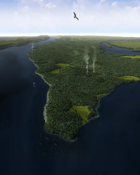
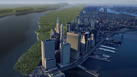 Markley Boyer & Eric W Sanderson, from Mannahatta: A Natural History of New York City
As NYC turns 400, one of the best ways of understanding what propelled the city’s astronomical growth is by paddling the rivers that built it.
Somewhere near Inwood Hill Park, home to the last native forests on the island of Manhattan, the jackhammering racket of the city softened and an orchestra of crickets trilled in unison. I paddled closer to the water’s edge, where a tangle of gnarled tree roots gripped boulders deposited during the last Ice Age. Just then, a great blue heron swooped low, landing on a small sandy cove before disappearing into the reeds towards the last remnant of the original salt marshes that once surrounded Manhattan.
“Finally,” I thought, after spending the day kayaking around one of the most man-made places on the planet. “Maybe this is something the island’s original residents might recognise.”
This year marks the 400th anniversary of the founding of New York City – or, more accurately, the Dutch settlement of New Amsterdam that would grow to become one of the world’s greatest cities. It’s a complicated milestone, and for years officials have been grappling over what, if anything, they should do to observe the event.

 Getty Images
As Russell Shorto, author of the best-selling book The Island at the Center of the World explained, this tiny Dutch settlement effectively birthed “the world’s first modern city” – a place powered by pluralism and capitalism under the promise that anyone, regardless of where they came from, could make something of themselves.
“If what made America great was its ingenious openness to different cultures, the small triangle of land at the southern tip of Manhattan island is the birthplace of that idea: this island city would become the first multiethnic, upwardly mobile society on America’s shores, a prototype of the kind of society that would be duplicated throughout the country and around the world,” he writes. More so than Boston, Plymouth Rock or Jamestown, “Manhattan is where America began.”
At the same time, the Dutch created this multiethnic society by removing Native people from their lands and importing enslaved Africans to build much of Lower Manhattan. “They brought tolerance and intolerance; capitalism and colonialism. We have to process both of these things in a nuanced way that acknowledges their achievements and failures,” Shorto told the BBC.
As a result, the few events honouring the city’s quadricentennial have tried to carefully balance how this settlement forever shaped the nation with its dark legacies of land dispossession and slavery. “We’re viewing this anniversary more as a commemoration as opposed to a celebration,” said Sarah Cooney, the executive director of the Holland Society of New York, which is co-sponsoring a picnic on 14 September at Governors Island, where the Dutch landed in 1624 before permanently settling in southern Manhattan soon after.
Those early immigrants never could have foreseen that the far-flung fur trading outpost they established would one day rise to become the most linguistically diverse city in history, nor that it would play host to a remarkable experiment that continues to this day: to see whether all the peoples of the world could live together in a single place.
 Getty Images
In many ways, Manhattan stands as the ultimate triumph of man over nature. But while it may be tempting to view it today less as an island and more as a cement reef covered by steel skyscrapers and manicured parks, the story of how this relatively small 23-square-mile enclave grew to become the economic capital of the world is directly attributable to a natural phenomenon many New Yorkers have long forgotten: its access to water.
“It’s all about the water. The entire city is about the water,” said Captain Jonathan Boulware, the president and CEO of the South Street Seaport Museum in Manhattan. “The growth of New York into the city we know today as a global capital, a cultural capital and a multicultural city, every single aspect of its identity is rooted in water and its connections to the rest of the world.”
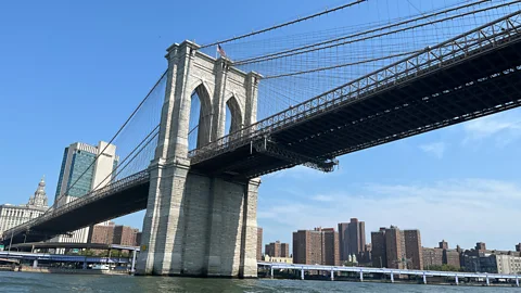
And so, as the city reflects on the many things that have made New York “New York” over the last 400 years, I lowered myself into a kayak and set out on a 30-mile circumnavigation of Manhattan in hopes of better understanding the one thing that made it all possible. It turns out that this nine-hour journey isn’t just one of the most unique ways of seeing New York City, but a dramatic reminder of how Manhattan is rediscovering its relationship to the very rivers that shaped it.
A front door into the New World
In 1609, Henry Hudson, an English explorer hired by the Dutch to find the fabled Northwest Passage to Asia, steered his ship from the churning waters of the Atlantic into an immense protected bay. He pushed 150 miles upstream on the mile-wide river that would one day bear his name, hoping it led to China. It didn’t. But while Hudson had failed to find a faster route to the riches of the East, he stumbled on one of the world’s largest natural harbours.
Sheltered from the sea’s wrath by Staten Island and Long Island and stretching across a 770-mile network of navigable waterways extending into the continent’s interior, this geographical gem wasn’t just “a safe and convenient haven, wherein 1,000 ships may ride in safety”, as the Dutch chronicler Adriaen van der Donck wrote in 1650, but a front door into the untapped resources of the New World.
 Getty Images
“The harbour of New York is like no other. It’s a marvel. It’s wide, it’s so deep it rarely freezes and it serves as the nexus for two bodies of water [the Hudson and East rivers] that come together to transport goods,” said Dr Louise Mirrer, president and CEO of the New-York Historical Society.
This immense commercial potential is what attracted the Dutch to Manhattan from the start. At a time when the most efficient way to move cargo over long distances was by water, the Dutch Republic catapulted from relative obscurity to become one of the wealthiest and most powerful nations in the world by controlling maritime trade. It’s also what made Manhattan distinct from other early US settlements. Unlike the Puritans who founded Boston, the Quakers who came to Philadelphia and the Catholics who arrived in Maryland, the Dutch didn’t settle Manhattan to worship in peace; they came to make money.
“The Dutch basically created a colony dedicated to capitalism. They didn’t really care about religion; they were open to anybody involved in commerce,” said Dr Gretchen Sorin, a historian and the director of the Cooperstown Graduate Program at the State University of New York at Oneonta. “And so from the very beginning, New York has always been an incredibly diverse place.” According to one document, by 1646 the island was home to some “400-500 men of different sects and nations” speaking about “18 different languages”.
But as Shorto explained, “Manhattan was a cultural crossroads long before Europeans arrived there. It wasn’t just the Lenape who used it to fish and exchange goods, but also the Shinnecock and other [Native Algonquin] peoples from the whole region who came to take advantage of the harbour and rivers.”
 Markley Boyer & Eric W Sanderson, from Mannahatta: A Natural History of New York City
After the Dutch purchased Mannahatta or “Island of Many Hills”, as it was known, from the Lenape in 1626, more and more seafaring entrepreneurs poured into the harbour to navigate up these rivers, shipping beaver pelts, tobacco and grain from the continent’s interior back to Europe. The Dutch eventually declared the settlement a free-trade zone in 1640, and by the time the British took it at cannon point in 1664 and renamed it after the Duke of York, this ambitious, polyglot little seaport had planted the seeds of religious tolerance, individualism and enterprise that would eventually spread across the nation.
Mannahatta: An ecological oasis
When the Dutch arrived on Mannahatta, it was a stunningly biodiverse place. In his book Mannahatta: A Natural History of New York City, landscape ecologist Eric W Sanderson details that in 1609 the island was home to 66 miles of rivers and streams, 233 species of birds, 32 types of reptiles and amphibians, 70 kinds of trees, 24 species of mammals and 55 different ecosystems – which is more, per acre, than Yosemite and Yellowstone or a typical coral reef or rainforest of the same size. “If Mannahatta existed today as it did then,” he writes, “it would be the crowning glory of American national parks.”
The British soon surpassed the Dutch as the greatest maritime empire on Earth and Manhattan became a nexus point for the flow of goods and people around the globe. Coopers, blacksmiths, sailmakers and shipbuilders began flooding to the island city, and by the 1770s, New York had become “the breadbasket of the Atlantic“, shipping wheat and timber to Britain and importing rum, molasses and sugar – as well as enslaved people – from the Caribbean and Africa. The city would burn at the end of the American Revolution, but over the next few decades, it would become the largest place in the western hemisphere – all thanks to water.
In 1795, New York replaced Philadelphia as the country’s main port, and as more ships from around the world flooded in and out of the harbour, the city expanded north from the southern tip of Manhattan at astonishing speed. Old Dutch farms and English estates were quickly carved up into smaller and smaller plots until DeWitt Clinton (arguably the greatest or worst New Yorker in history) spearheaded two ideas that would forever change Manhattan.
The first was to level the entire natural geography of the island to accommodate its growing seaport. In 1811, the city filled in its marshes, paved over its spring-fed ponds and levelled the oak and hemlock forests where wolves and bear once roamed, replacing it all with a massive 11,000-acre street grid that turned this “island of hills” into an island of rectangles.
 Alamy
AlamyThe second was the construction of a 363-mile-long ditch connecting the Hudson River to the Great Lakes. When the Erie Canal opened in 1825, it not only paved the way for Manhattan to become an industrial juggernaut by giving it direct water access to the Midwest, but transformed the young nation by allowing the mass movement of goods, ideas and people across the country. The city was on its way to becoming the busiest port in the world and the centre of a new global supply chain connecting the continent with the rest of the globe. As Manhattan exploded with industry and became the place to do business, so many immigrants steamed into the harbour that according to Census records, by 1860 nearly 70% of adults in New York City were born outside the US.
Manhattan: America’s emporium
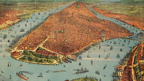
The book Gotham: A History of New York City to 1898 reveals that by 1836, 62% of all imports to the US came through Manhattan, and on a single day that year, 921 boats on the East River waited to dock on South Street, while an another 320 waited on the Hudson.
“If you look at aerial photos of Manhattan [in the late 1800s and early 1900s], it’s so completely ringed with piers that it looks like a porcupine,” Boulware said. “These ships were coming from all over the world to load and unload cargo, and there were a lot of entrepreneurs trying to creatively turn $5 into $6 on those docks. It was an early example of the New York hustle. This is the DNA of the city and the port and water is the core of it.”
As planes started replacing passenger liners and container ships were diverted to New Jersey in the 1950s, Manhattan’s maritime industry began to collapse. Over the coming decades, piers and warehouses were abandoned, docks fell into decay and New York Harbor, which had been one of the most diverse and dynamic environments on the planet when the Dutch showed up, became a de facto dump.
But in the last decade, billions of dollars have been pumped into cleaning up the city’s waterways, a string of ambitious projects have transformed Manhattan’s rusting piers into landscaped green spaces and the city’s once-derelict waterfront has become a model of urban renewal. As a result, more than four centuries after Hudson’s crew reported that waves of Lenape came out to greet their ship in “great canoes” as they approached the island, Manhattan is returning to its water-bound roots, and quickly emerging as one of the US’s most unique paddling destinations.
 Alamy
Alamy“There’s no place like it in the country,” said Suzy Basu, managing partner of Manhattan Kayak Co, which offers hourly rentals, private classes and guided tours around the city – including a 30-mile lap of Manhattan. “So many people here don’t even realise Manhattan is an island, but when you paddle around this magnificent, man-made mountain range of towers shooting into the sky, it changes your whole perspective of the city. You’ll see.”
Kayaking Manhattan
Pushing out of Pier 84 and into the Hudson’s swift tidal flow, it quickly became clear that the key to navigating Manhattan’s waterways on your own power is something the island’s Indigenous residents understood long ago: it’s all about the current.
The original Algonquin name for the Hudson River was Mahicantuck or “river that flows two ways”. That’s because, like the East River that rings Manhattan’s opposite end (which isn’t actually a river but a tidal strait), its current changes direction every few hours as it flows in and out of the ocean. Therefore, our floating parade of 14 kayakers and four stand up paddleboarders would travel counterclockwise around the island in a perfectly timed route designed to take advantage of the rivers’ shifting currents.
Accompanying us were three guides armed with two-way radios whose job was to safely navigate us through the rush of ferries, barges and sightseeing cruises – one of whom was Eric Stiller, Manhattan Kayak Co’s 64-year-old founder, who estimates he’s circumnavigated the island 80 to 100 times. He explained that back in the 1980s, there was no access to the water for paddlers anywhere, so he used to jump fences and launch his foldable kayak in the Hudson from rotting piers. As word of his exploits spread, people started paying him to lead them out into the rivers where no one else dared go.
“My first paying customer was [American singer] David Lee Roth, followed soon after by John F Kennedy Jr,” he said, as we paddled towards the glimmering pinnacles of the Chrysler and Empire State buildings in the distance. “We used to wheel kayaks out [in the Meatpacking District], jump the fence and paddle out to Ellis Island. That’s how this all started.”
As the current carried us south along the 550-acre Hudson River Park that runs along Manhattan’s western shore, the island’s recent waterfront revival unfolded in front of us. Since first opening in 1998, the park has been slowly transforming many of the collapsing piers that once propelled the city’s growth into creative urban oases – all while paying homage to Manhattan’s maritime past and incorporating native ecosystems that thrived here 400 years ago.
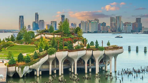
We soon paddled past Little Island, a $260m “floating park” rising like a bouquet of tulip-shaped concrete columns from the Hudson that opened in 2021. Built atop the former Cunard Line dock that shipped people and goods between Manhattan and the British Empire (and next to the pier where the survivors from the Titanic landed in 1912), it’s home to 350 species of flowers, trees and shrubs that Mannahatta’s early residents would recognise today.
Moments later, we drifted past Gansevoort Peninsula, where novelist Herman Melville spent years working as a customs inspector at the wharf after writing Moby Dick. Opened in 2023, the park features a restored marsh, native grasses and a 1,200-ton sand beach designed to mirror those that lined the island’s western shore when the Dutch arrived.
 Getty Images
Tribeca’s 2.5-acre “ecologically themed” Pier 26 then came into view, where a newly planted woodland forest, coastal grassland and maritime scrub is designed to mimic the river’s original coastal habitat. A brand-new “estuarium” opened in January 2024 featuring a playground inspired by fish species that thrived in the Hudson before European colonisation, and as I looked to my left, I spotted children climbing into the gills of a colossal Atlantic sturgeon.
Work is underway on the other side of Manhattan, too, where the East Midtown Waterfront project is part of a grand vision to close the loop and provide New Yorkers with continuous waterfront open space around Manhattan once it’s completed in 2026.
As we approached the southern tip of Manhattan where the Dutch settled, a sudden “Hold!” command from Stiller thrust me back into the present. Four centuries later, these waters remain the Manhattan’s busiest maritime throughfare. With boats and barges rumbling all around us, Stiller explained that once he gave the signal, we had exactly 10 minutes to round the island’s southern point before the next Staten Island ferry stormed by.
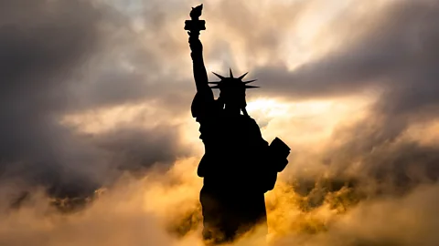
I glanced over at the Statue of Liberty and Ellis Island on my right, One World Trade Center on my left and snapped a quick picture with my phone. Then, one of our guides, Tommy Montgomery said, “You’re going to want to secure that now before we get to Hell Gate.”
“Before we get to what?” I asked.
But before he could reply, Stiller shouted, “Now, now, now!”
 Eliot Stein
Paddling as hard as we could, our crew quickly crossed the channel, caught the East River’s flood tide and shot north on an 11-knot (12.5 mph) highway past the last 19th-Century cargo sailing ship still docked at the historic South Street Seaport and under the Brooklyn, Manhattan and Williamsburg bridges. At one point, I noticed we were zipping past a kid biking along the East River Greenway. As we neared the northern tip of Roosevelt Island, Montgomery looked back at me.
“Okay, this” he said, “this is Hell Gate. Stay to the left and paddle hard.”
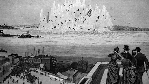
Coined by the Dutch (Helle Gadt) and known as the most notorious stretch of the city’s complex waterways, Hell Gate is the swirling, churning, narrow tidal strait where the Harlem and East rivers meet. It’s also the final resting place of hundreds of ships. But because successfully traversing it could save merchants sailing from New York Harbor to New England days of travel, so many sailors tried to run its gauntlet that in the 1850s, an estimated 1,000 ships ran aground here every year. In 1885, at the height of Manhattan’s maritime might, officials determined that subduing this treacherous passageway was so crucial to the nation’s economy that the US Army Corps of Engineers blew up its bedrock with 300,000 lbs of explosives in the largest planned detonation before the atomic bomb.
Today, the confluence remains chaotic and unpredictable – akin to “paddling through a whirlpool”, as Stiller later told me – but with the currents working in our favour, we were soon beached at Randall’s Island.
One of the consequences planners likely didn’t consider when they paved over Manhattan’s natural topography is that there are virtually no places people can feasibly stop when kayaking around it – even for a bathroom break. A rocky beach on Randall’s Island is one of the few exceptions. So as the other paddlers downed their energy bars and I tucked into my bodega sandwich, I took a moment to meet them.
 Alamy
AlamyOf the group’s 17 other rowers, 11 were women and only one other person had never completed “the circ”. There was Nick Avrutin, who said he spends so much time paddling with Manhattan Kayak Co that he now stores his kayak at the boathouse; Stacey Hull, who was attempting her first circ on a stand up paddleboard after many in a kayak; and Giandomenica Becchio, who travels from her home in Turin, Italy, to New York every summer to lap the island.
“When you get on the water, it really gives you a different perspective of what the city is,” said Eva Rivlin, looking down at a crab that had washed up on the beach. “Our shorelines are these incredible, diverse ecosystems, and to see it from this perspective, you really understand not only the scale of the city but how it all fits together.”
“People still have this perception that the water is dirty and not safe, and it’s still dirty, but it’s incredible the developments in the last 15-20 years that have changed it by leaps and bounds,” Rivlin said.
 Alamy
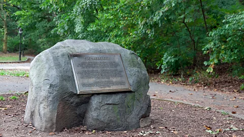
AlamyTwo hours and 13 bridges later, we had finally paddled our way out of the Harlem River’s modern industrial sprawl and reached the island’s northern tip at Inwood Hill Park, where Mannahatta’s primordial past still defies Manhattan’s paved presence. It’s perhaps fitting that here, just a few steps from a series of caves used by the island’s Native inhabitants for millennia, a 1,000-year-old rock marks the site where the Lenape purportedly sold the island to the Dutch four centuries ago.
Moments after I watched the heron vanish into the reeds, the trilling of crickets was swept aside by the whooshing traffic and whirring helicopters of the city. My fleeting glimpse of Mannahatta was gone – or so I thought.
As we waited for the Hudson’s current to shift so it could carry us south towards the soaring skyscrapers of Midtown, it occurred to me that for as much as this island had changed in the last 400 years, one part of its natural landscape remained the same – and it had been guiding me around Manhattan all day.

New York Subway Horror: Man sets sleeping woman on fire in train car – Full story here – World News

G League Knicks Win Back-to-Back In-Season Championships

Giants Take on Sole Possession of Top Spot in 2025 NFL Draft

Where is there even hope for Giants at this point?

NYC firefighter unions blast House decision to strip funding for 9/11 health care program

Sleeping woman set on fire on New York subway

Man Sets New York Woman On Fire, Watches Her Burn To Death Inside Train

Falcons QB Michael Penix Jr. Validates Belief in ‘Almost Flawless’ First Start

Who is Sebastian Zapeta? Guatemala migrant set a woman on fire on New York City subway
