Travel
NYC area sees flooding: 3–5 inches of rain expected | Weather Forecast

NYC weather forecast: When will the rain go away?
FOX 5 NY’s Nick Gregory has your weather forecast.
NEW YORK CITY – Severe thunderstorms with heavy rain caused widespread flooding across the New York City area.
The storms are expected to bring 3′ to 5′ inches of rain, damaging winds and flash flooding.
Here’s everything you need to know about today’s potential for severe weather, including radar, outlooks, timing, impacts, flight delays, power outages, and the latest on Tropical Storm Debby.
JUMP TO: RADAR l OUTLOOK l TIMING l IMPACTS l DEBBY
***Click each headline to jump to the designated topic.
Weather in NYC today
This graphic shows the flash flood threat on Tuesday, Aug. 6, 2024. (FOX Weather)
A flood watch is in effect for parts of the New York City area now through Wednesday morning. The National Weather Service also issued a severe thunderstorm watch for parts of New Jersey, New York and Pennsylvania until 11 p.m.
The New York City Emergency Management Department has also issued a travel advisory.
“Showers and storms will develop as the day goes on with the potential flooding especially later tonight and into tomorrow morning,” FOX 5 NY’s Mike Woods said in a post on X, formally Twitter.
Click HERE for more information.
Much of New Jersey is under a slight risk for severe weather, while other parts of the Tri-State area, including NYC, are under a marginal risk.
Parts of central NJ have been placed in a Level 2 out of 5 risk on the NOAA’s Storm Prediction Center’s (SPC) 5-point severe thunderstorm risk scale.
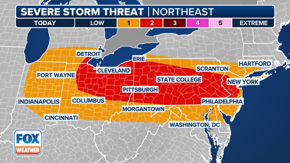
This graphic shows the severe weather threat on Tuesday, Aug. 6, 2024. (FOX Weather)
“In either one of those, you could see some stronger storms with heavy rain, gusty winds, small hail and, every once in a while, an isolated tornado,” Woods said. “Just a little more likely for you in the yellow-shaded area.”
Meanwhile, NYC is under a moderate risk for excessive rainfall, which means numerous flash floods are likely, according to the NWS.
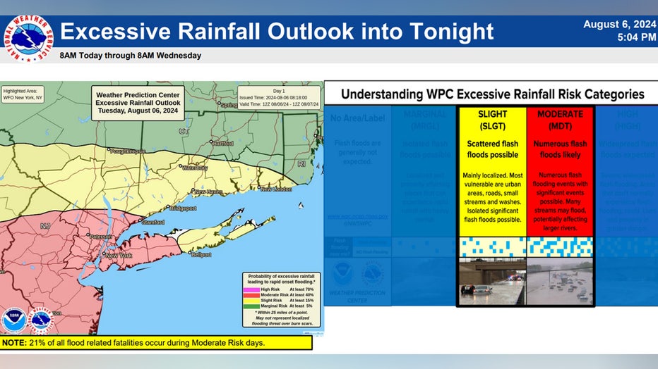
Excessive rainfall outlook. (NWS)
The chances for rain should pick up as the night progresses.
“Kind of scattered at first in the afternoon and evening, and then it becomes heavier and more solid as we head through the later evening and into the overnight hours and even into tomorrow morning,” Woods said.
The National Weather Service says local amounts of 3 to 5″ of rainfall are possible “where numerous thunderstorms move over the same area.”
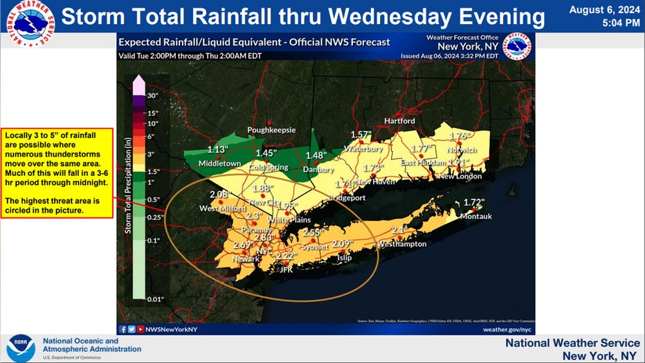
Storm total rainfall. (NWS)
“It’s a decent stretch of fairly heavy rain that comes by,” Woods said. “About 1 to 2 inches of rain wants to come through with this.”
Rainfall rates are expected to be 1 to 2″ an hour (Locally 3″) this afternoon into early Wednesday morning. NOAA’s Weather Prediction Center (WPC) has placed NYC in a Level 3 out of 4 risk of flash flooding on Tuesday.
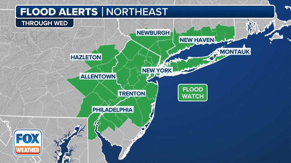
This graphic shows the flood alerts in effect through Wednesday, Aug. 7, 2024 (FOX Weather)
“Scattered to numerous instances of flash flooding of urban & poor drainage areas and along quick responding rivers & streams are possible,” the National Weather Service said.
The NWS says the flooding could be locally significant, “causing major disruptions to transportation.”
There are currently ground stops at LaGuardia, JFK, and Newark Airport, according to the National Airspace System status.
NYC flight status
Check the status of each airport below:
LaGuardia Airport delays
- For more information from the FAA, click HERE.
Newark Airport flight status
- For more information from the FAA, click HERE.
JFK Airport flight status
- For more information from the FAA, click HERE.
NJ Transit delays
“Rail service into and out of Penn Station New York is subject to up to 15-minute delays due to weather-related equipment availability issues,” NJ Transit said in a post on X.
NJ Transit also said the Morris and Essex Line rail service is suspended in both directions between Dover and Summit due to weather-related loss of power to overhead wires.
River Line service is suspended in both directions between the Waterfront Entertainment Center and Walter Rand Transportation Center due to flooding conditions in Camden, NJ Transit said.
According to Poweroutage.us, New Jersey currently has 10,917 customers without power as of 10 p.m.
In New York, Poweroutage.us says there are currently 3,059 customers without power as of 10 p.m.
Weather in New York tomorrow
Showers are likely and possibly a thunderstorm. Cloudy, with a high near 71. The chance of precipitation is 70%.
NYC weather this week
- Wednesday: Showers likely and possibly a thunderstorm. Cloudy, with a high near 71. The chance of precipitation is 70%.
- Thursday: A 40% chance of showers and thunderstorms. Mostly cloudy, with a high near 77.
- Friday: Showers and possibly a thunderstorm. High near 79. Chance of precipitation is 90%.
Remnants of Tropical Storm Debby could also bring additional heavy rain from Thursday into Saturday.
Through Sunday, several inches of rain could fall along the East Coast, with the highest totals centered near and along the Interstate 95 corridor from the mid-Atlantic to the Northeast.
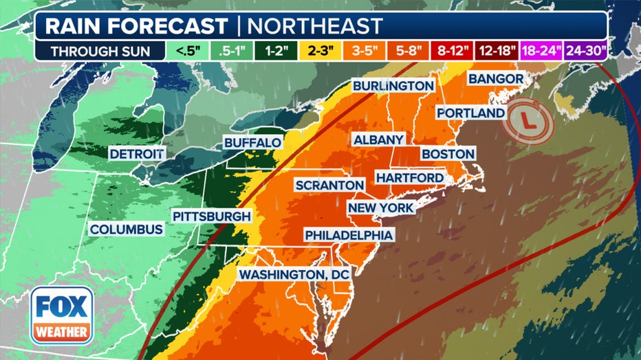
This graphic shows the forecast rain totals through Sunday, Aug. 11, 2024. (FOX Weather)
Widespread rainfall totals of 5-8 inches are expected, with locally higher amounts possible where the heaviest rain bands set up.
FOX Weather helped contribute to this report.


![[!LIVE-FOOTBALL@!]+ Commanders vs Eagles Live Stream ! Atlanta Falcons vs New York Giants LIVE , player stats, standings, fantasy games TV channels and more HS8079 [!LIVE-FOOTBALL@!]+ Commanders vs Eagles Live Stream ! Atlanta Falcons vs New York Giants LIVE , player stats, standings, fantasy games TV channels and more HS8079](https://www.reddotdigitalit.com/wp-content/uploads/2021/05/Streaming-Platform.jpeg)


