
Travel
NYC Debby tracker today: Tornado watch issued in NJ, NY

NYC weather forecast
Mike Woods has the forecast, including what NYC can expect from Debby today.
NEW YORK – Debby, a hurricane turned tropical depression, is expected to hit NYC on Friday. Though the storm has tracked westward, softening its blow to the Tri-State, the National Weather Service issued a tornado watch for parts of New York and New Jersey.
The storm will also bring periods of heavy rain, severe isolated thunderstorms, strong winds and dangerous rip currents.
LIVE RADAR HERE | THREATS FORECAST | TIMELINE
New York City Emergency Management issued a travel advisory for Friday due to the threat of rain and flooding. Flight delays and commuter headaches are expected.
Debby has killed at least seven people in its slow trek up the East Coast, according to FOX Weather.

Here’s everything you need to know about Debby’s threats to the NYC area, a timeline for the storm and when, finally, the rain will stop:
Tornado watch
A tornado watch was issued for most of northern New Jersey and parts of New York’s Lower Hudson Valley, including Orange and Sullivan counties. The watch is in effect until 2 p.m.
As Debby mixes with an area of low pressure, severe thunderstorms will bring a tornado risk, according to the National Weather Service in New Jersey.
“A more inland track of the remnants of Debby places our region in the more favorable zone for the tornado risk,” the agency reported.
Rain totals and flooding threats
NOAA’s Weather Prediction Center (WPC) placed much of our area under a Level 2 out of 4 flood risk on Friday. New York City, which experienced rounds of torrential rain, flooding and severe weather on Tuesday, has been placed in a Level 1 flood threat.
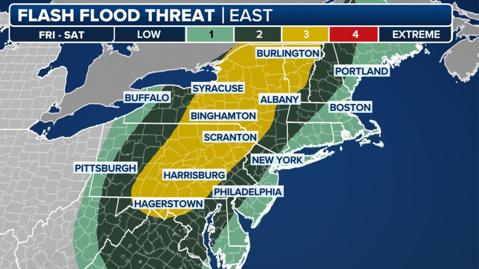
About 1 to 3 inches of rain are expected in New York City and the surrounding suburbs. The NWS still warns of scattered flooding throughout urban areas.
New Jersey can expect the most rainfall, and rivers may crest after a week of consistent rain.
Long Island and southern Connecticut will see less, around 1 inch.
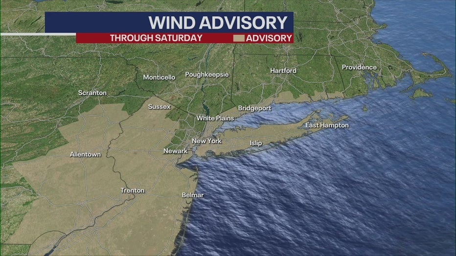
Winds
The system could bring gusts up to 50 miles per hour to Long Island and New York City, according to the National Weather Service.
Friday morning
During the morning commute, expect cloudy skies before the storm approaches NYC from the west.
A secondary threat of isolated to scattered severe storms with damaging wind gusts is also expected for Friday morning.
Friday afternoon
The storm connects with the cold front and hits New Jersey first, followed by New York, before moving north.
At this point, isolated severe thunderstorms could bring strong wind gusts and possible tornadoes to the area.
Friday evening
The storm will reach its peak between 7 p.m. and 9 p.m.
Saturday morning
The storm will clear by Saturday morning, but river flooding threats could linger.
Sunday morning
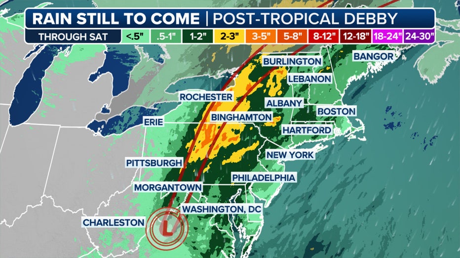
Through Sunday, many locations in New York could see an additional 3 to 5 inches of rain from what’s left of Debby, according to FOX Weather.
Debby’s path
After the first landfall, Debby slowed down significantly as it spun across northern Florida and Georgia, eventually making its way into the Carolinas where it dropped feet of rain and triggered countless reports of flooding.
Debby then moved offshore over the open ocean before swinging back toward the East Coast of the U.S., making its second U.S. landfall in South Carolina with winds of about 50 mph.

Crews work to help water drain as homes are flooded in the Tremont Park neighborhood August 6, 2024 in Savannah, Georgia. (Megan Varner)
At least seven people have been killed due to Debby’s impacts, and power was knocked out to hundreds of thousands of utility customers across the Southeast.
The FOX Forecast Center said that on Friday, Debby, which will be quickly transitioning from a tropical storm to a post-tropical storm, will be pushing through interior portions of the Northeast.

While on patrol, a Bladen County deputy’s vehicle occupied by two deputies was nearly missed by a large tree that fell Wednesday eveing. (Bladen County Sheriff’s Office)
The extreme amounts of tropical moisture still being produced by the storm, combined with a dip in the jet stream off to the west, are expected to produce heavy precipitation from the central Appalachians through the interior Northeast and northern New England.
– from FOX Weather

New York State Braces for Arctic Chill: Highs in the 20s on Sunday, Travel Caution Advised

Arajet Launches New US Routes in 2025, Connecting Dominican Republic with New York, Miami, and Puerto Rico, Enhancing Travel Across the Americas – Travel And Tour World

Why the cheapest team in US sport is finally spending money… at the weirdest possible time

Knicks Injury Report: Concerns Ease Over Josh Hart’s Sudden Absence as Availability vs Pelicans Unravels

Nationwide Amazon strike expands to Staten Island warehouse workers: ‘Will not be stopped’

Giants $3.7 million starter predicted to leave New York for Bengals | Sporting News

NBA Legend Charles Barkley Makes Bold New York Knicks Statement

Kim Kardashian takes up her ‘first job in retail’ at new NYC store

Security guards tackle two women to the ground during Knicks-Timberwolves game after they ran onto court
